The team’s design transformed the Bergen Arches stretch into a greenway, connecting it to existing trails by extension of the Essex-Hudson Greenway. This provided an 11 mile stretch of pedestrian pathway that connects Montclair to Jersey City, creating a commuter and recreational use for the surrounding community.
Ramps were designed to take pedestrians and bicyclists from street level down to the trail. Stormwater was assessed and a swale drainage system was designed to mitigate the runoff and ensure functional trail use. The intersection was redesigned to accommodate traffic congestion.
Spring Design
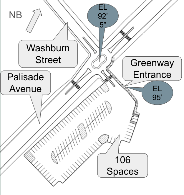
Julie designed the new multi-use pathway for the greenway. She focused on the transportation aspect, and created pedestrian-access to surrounding attractions by means of non-vehicle transportation. The intersection was changed to a roundabout and a parking lot was designed for greenway users.
Erin designed a swale drainage system for the overall length of the greenway. An analysis of the overall watershed area and the greenway and the pedestrian boardwalk itself was analyzed and used to design the drainage system. 1-Dimensional and 2-Dimensional analyses based on a 24 hour 100 year storm event were simulated through the swale drainage system.

Maria designed an ADA accessible ramps and staircases for the Bergen Arches stretch. The Bergen Arches are not at the same elevation of the street level. The street level is 45 feet higher than the depressed ground level, not allowing the public an easy access to the trail. Ramps and staircases allowed all users to get from street level down to the trail.


Abstract
The Bergen Arches refer to an old, abandoned set of rail lines in Jersey City, New Jersey.
The stretch of land was repurposed to create a pedestrian greenway. A traffic count at the
intersection of the greenway entrance and main road revealed long queue lines and stand-still traffic, with an average of 1,400 vph. The intersection was redesigned as a peanut-shaped mini-roundabout featuring a 4’ wide apron and 9’-3” radius. A parking lot for users was designed for access to the trail. Since the greenway lies 45’ depressed from street level, a concrete ramp and concrete staircase were designed. The first three sections of the staircase had a span of 17.5’ and the last section had a span of 13’. Reinforcement for the staircases included main #11 rebar spaced at 6” and longitudinal #4 rebar spaced at 12”. The ramp was designed to have five spans of 126’. Reinforcement for the ramps included main #18 rebar spaced at 12” with landings of #8 rebar spaced at 12”. A rainfall runoff analysis was done to make sure that flooding does not occur on the pedestrian pathway. As a result of the proposed walkway, a peak volume of 10.4 𝑥 10^4 𝑓𝑡^3 and peak flow of 7.4 cfs were used as parameters for the swale drainage system design. The swale was designed as 3’ depth x 10’ width with a side slope of 3:1. The engineering cost estimate for the entire year was $51,000 and the estimated construction cost was $1,103,000.
Spring Update – Final Presentation
https://docs.google.com/presentation/d/1UXOH-6n32wyzJesRP3UNc-um6DQ-GATBRW6ce7qEzCs/edit?usp=sharing