Fall Semester Update
Throughout the fall semester, significant progress was made in data collection, site analysis, and the development of design solutions for Hoboken Terminal. Three alternative designs were proposed to enhance multimodal accessibility and alleviate congestion in the area.
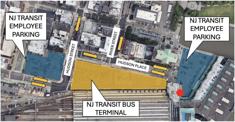
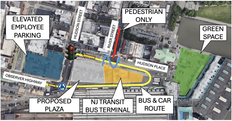
Each alternative aimed to optimize car parking, improve multimodal traffic flow, and incorporate a pedestrian plaza to replace underutilized space currently occupied by the NJ Transit Bus Terminal. The proposed plazas prioritize sustainability, enhance pedestrian accessibility in and around the terminal, and maintain the site’s historic character. The first two alternatives involve rerouting vehicular traffic around a smaller pedestrian plaza and redesigning key intersections, effectively reducing vehicular presence near the terminal entrance by restricting traffic on select streets. For the first alternative, traffic flows in the counterclockwise direction along the Observer Highway and Hudson Place route. A geometric change for the intersection of Observer Highway and Hudson Street is proposed along with a change to the existing signal timing at the intersection of Hudson Street and Hudson Place. These changes are proposed to alleviate vehicular congestion and accommodate pedestrian accessibility in the area.
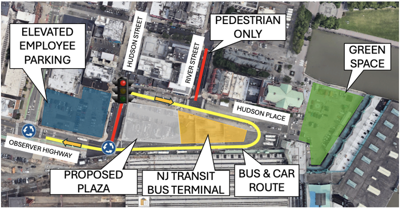
For the second design alternative, traffic flow runs in the clockwise direction along the Hudson Place and Observer Highway route. A roundabout for the intersection at Observer Highway and Hudson Street and Observer Highway and the adjacent intersection to the west is proposed along with a change to the existing signal timing at the intersection of Hudson Street and Hudson Place. These changes are proposed to similarly alleviate vehicular congestion in the area and provide accommodation to pedestrian accessibility.
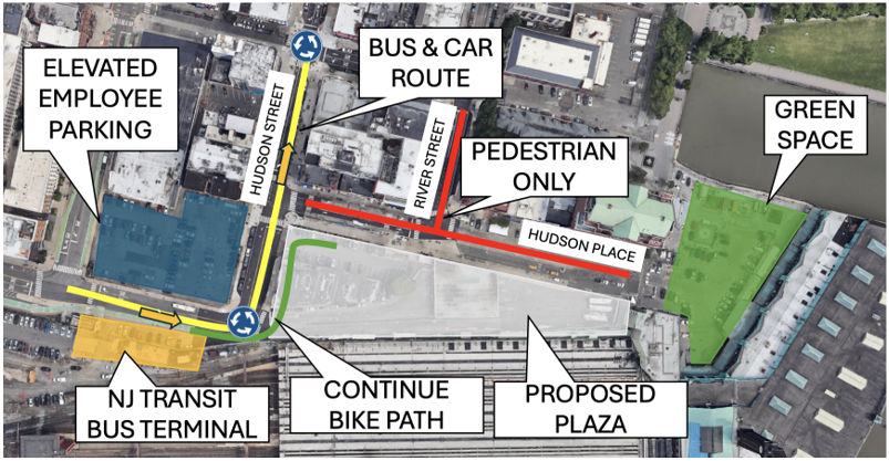
The third alternative eliminates vehicular traffic near the terminal entirely, replacing it with an expansive pedestrian plaza which serves as a dedicated path for pedestrians and bicyclists to travel to the terminal. The bus terminal is relocated to the region just south of Observer Highway. Changes to the existing geometry at the intersections of Hudson Street and Observer Highway and the adjacent intersection to the north are proposed to alleviate congestion and accommodate the changes to traffic flow for vehicles, pedestrians, and bicyclists.
Traffic counts conducted during a site visit revealed an average hourly volume of 265 vehicles, 1,862 pedestrians, and 22 bicyclists. Based on this data, the third Alternative Design 3 was selected as the final design, since it prioritizes traffic reduction, sustainability, and pedestrian accessibility the most out of each alternative.
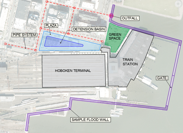
For stormwater management design alternatives, watershed analyses of the Hudson River and Hoboken Terminal watersheds were conducted to inform design requirements for site improvements. Hydrologic modeling using HEC-HMS, based on a 24-hour, 100-year storm event, estimated a direct runoff volume of 44.2 acre-feet and a peak discharge of 180.5 cubic feet per second. Hydraulic modeling of the Hudson River in HEC-RAS was used to determine that the river overtops at roughly 5.74 ft. during a 24-hour 100-year storm event. These analyses informed the decision to include a floodwall to manage flooding due to the overtopping of the Hudson River and to redesign the existing stormwater pipe network to more adequately handle flooding due to excess rainfall runoff. An image with a sample geometry for the stormwater design alternatives is provided. A sample floodwall is shown in purple with the inclusion of a gate to allow for the free travel of ferries during operation hours. Additionally, a sample geometry for the stormwater pipe system is displayed in red.
The team concluded the semester with a final fall presentation of engineering services, which can be accessed through the link below.
Improvements to Hoboken Terminal Corridor Final Fall Presentation