The hydraulic and transportation elements of County Route 626/Lomasons Glen Road and Bridge No. 23073 over Buckhorn Creek Tributary in White Township, NJ, were redesigned for improved safety. In 2022, a storm caused total road failure downstream of the bridge, as sections of the roadway collapsed on the tributary side, leading to road closure. This project employed levee walls for scour protection, redesigned the cross-section below the bridge to preventing overtopping, and incorporated roundabouts for safer intersections. Levee walls improved integrity of the river embankments and provided floodplain management. Runoff volume was calculated using a gridded distribution of curve numbers, a 1.13-square-mile drainage area, and 2.94 in/hr rainfall intensity, yielding a 150 CFS peak flow. A 20-foot long, 24-foot wide, open-bottom bridge with a deck thickness of 1 foot was favored for stream stability and ecological preservation. This proposed bridge is located 10 feet upstream from the existing bridge and by implementing this, it increased the overall flow rate capacity of the tributary. For traffic planning, roundabouts were evaluated at Lomasons Glen Road and Belvidere Road (Location 1) and at Lomasons Glen Road, Buckhorn Drive, and Summerfield Road (Location 2). Belvidere Road saw peak-hour traffic of 862 vehicles, with some exceeding its 50-mph limit at upwards of 70-mph. Lomasons Glen Road hadlower traffic and lacked pedestrian/bike space from narrow lanes, benefitting from an intersection redesign. At Location 1, a peanut roundabout with a 101’ outer diameter, 51’ center island, and 12’ truck apron was implemented. At Location 2, a mini roundabout with a 75’ outer diameter, 26’ center island, and 9.5’ truck apron was used. Due to space limitations, altering roadway geometry for pedestrian/bike lanes wasn’t viable, improved signage and striping were prioritized. The estimated total cost of construction and engineering services was $1,450,000 and $47,000 respectively.
During the spring semester, our team finalized both our transportation and hydraulic designs for Lomasons Glen Road.
Link To Final Presentation:
Transportation Design Summary
The transportation component of the County Route 626/Lomasons Glen Road rehabilitation project focused on addressing critical safety concerns at two key intersections through innovative roundabout designs. At the intersection of Lomasons Glen Road and Belvidere Road, a peanut-shaped roundabout was implemented to mitigate high-speed traffic issues, as data showed approximately 10% of vehicles exceeded the posted 50 mph speed limit. This intersection experienced significant traffic volumes, with peak hour counts of 828 vehicles. The roundabout design incorporated a 101-foot outer diameter, 51-foot center island, and 12-foot truck apron to accommodate both passenger vehicles and larger commercial traffic. This design significantly improved safety while enhancing connectivity between commercial establishments located on opposite sides of Belvidere Road.
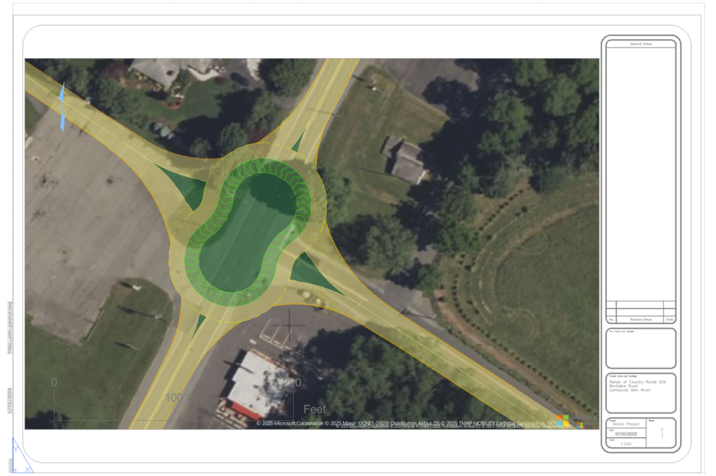
Final Roundabout Design at Lomasons Glen Road and Belvidere Road
The second intersection at Lomasons Glen Road, Buckhorn Drive, and Summerfield Road presented different challenges, primarily inadequate sight distance creating a hazardous blind left turn from Buckhorn Drive. Here, a mini-roundabout was designed with a 75-foot outer diameter, 26-foot center island, and 9.5-foot truck apron. Although this intersection experienced lower traffic volumes (approximately 26 vehicles during peak hours), the roundabout effectively resolved safety concerns while optimizing the limited space available at this junction. Throughout the corridor, strategic placement of W11-15 and W16-1P signage was incorporated to enhance awareness of potential bicycle and pedestrian traffic. All roadway designs maintained standard 11-foot lane widths in accordance with NJDOT Roadway Design Manual requirements. Comprehensive traffic studies informed all design decisions, with Synchro Studio modeling validating the effectiveness of the proposed solutions.
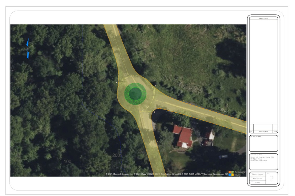
Final Roundabout Design at Lomasons Glen Road, Buckhorn Drive, and Summerfield Road
Hydraulic Design Summary
The hydraulic design component of this project addressed the catastrophic failure that occurred in 2022, when a major storm event caused complete roadway collapse along County Route 626. The centerpiece of the hydraulic solution was a 20-foot long, 24-foot wide open-bottom bridge with a 1-foot deck thickness spanning the Buckhorn Creek Tributary. This natural bottom design was selected over alternative culvert options to preserve the ecological integrity of the waterway while providing sufficient capacity for major storm events. Detailed hydraulic modeling verified 1.67 feet of bridge clearance during 100-year storm events, with the structure designed to handle peak flows of 150 CFS.
.png")
Cross Section of Proposed Bridge over Buckhorn Tributary
Comprehensive scour protection was implemented through strategically placed concrete levee walls at four critical locations along the tributary. Levee Wall 1 extended 70 feet from elevation 153.8 feet to 151.7 feet, while Levee Wall 2 provided downstream protection for 390 feet, descending from elevation 151.7 feet to 118.5 feet. Levee Walls 3 and 4 measured 60 feet and 160 feet respectively, protecting the upstream approaches to the bridge. All walls were constructed with 2-foot width and extended 2 feet above ground level to prevent overtopping. Concrete levee walls were selected after careful analysis, as they provided superior protection against extreme hydraulic forces and effective seepage control compared to alternative solutions such as gabion baskets or riprap. The locations of each concrete levee wall are shown in the figure below.
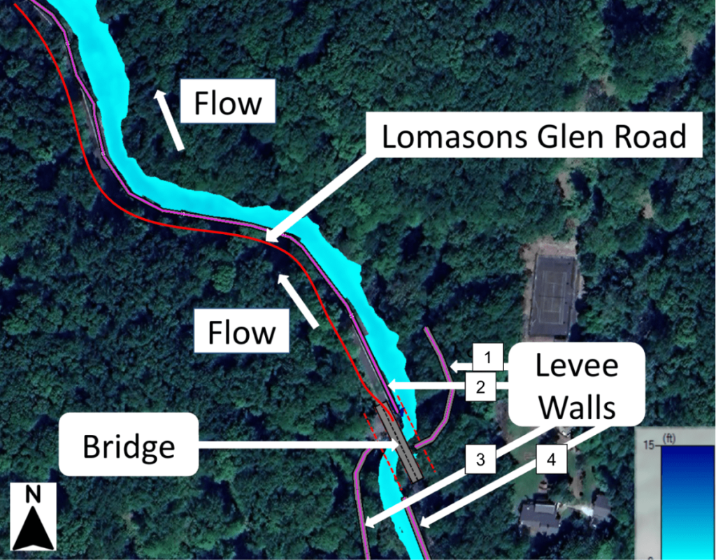
Location of Levee Walls on Lomasons Glen Road
The drainage system incorporated culverts placed at 50 foot intervals along the every levee wall, efficiently channeling mountain runoff into the tributary while preventing water pooling on the reconstructed roadway. These culverts which acted as drains are 1’x1′ in dimension and have flood flaps on the tributary side of the levee wall. The flood flaps allow for drainage from the mountains runoff to flow into Buckhorn Creek Tributary, while preventing any backflow if the depth of the tributary exceeds the height of the culvert drain. Extensive HEC-RAS 2D unsteady flow analysis demonstrated significant improvement in floodplain management compared to pre-failure conditions. The designed system successfully contained the 100-year storm event within the embankment, eliminating any roadway overtopping that caused the original failure. This comprehensive hydraulic approach delivered both immediate restoration capabilities and long-term resilience, ensuring the reconstructed infrastructure can withstand future extreme weather events while preserving the natural characteristics of the waterway.
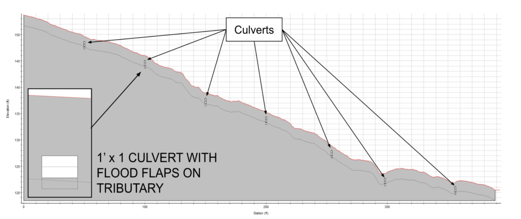
Lower Levee with Culverts used for Draining