
Purpose
As The College of New Jersey, TCNJ, increases its student and faculty size, there is an ever increasing need to provide additional occupancy and coordination to accommodate its growth. One area where coordination can be improved is related to campus parking. Parking on campus is limited to eighteen locations throughout TCNJ and can be filled, and on occasion overflow to the lawns, rather quickly by students, faculty and visitors. On a typical day, many drivers attempt to find a parking space by driving around to different parking lots and essentially guessing where parking spaces are available. This guesswork is inefficient for drivers who must drive around campus in search of space to park.
The Parking Lot Availability System is an end to end service that allows commuters to see available parking spots for a given lot. The idea began in response to students who lived off-campus who struggled to find parking spots when they came to campus. The lots often get crowded which meant that the students were losing time searching multiple parking lots for a space. The proposed solution to this was to monitor the number of available spaces in each lot so that drivers could easily check where they could park without physically driving between campus parking lots.
The system features three modules that will work together to collect, transmit, and display the status of each parking lot. One module, the detection unit, will feature a custom printed circuit board that contains an ATMEL microcontroller, an Ultrasonic Distance sensor, a ST Electronics Time of Flight Distance Sensor, a custom power subsystem for renewable operation, a wireless radio, and other components for the unit’s operation. The second module, the base station, will broadcast and route detection unit payloads using a wireless network with a Arduino compatible microcontroller, a wireless radio, and a microcomputer. The third module, the cloud web server will receive the status of a parking lot and store the status for each parking lot in a PostgreSQL relational database. Each module will be programmed using either C, C++, Javascript, and other web languages. Each module’s code base not only includes software for its operation but also unit tests that verify its functionality, independent of current progress of neighboring modules.
Architecture
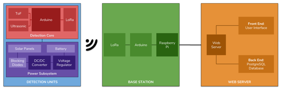
Detection Unit
The Detection Unit is a device that is placed at the entrance and exit to each of the parking lots that are to be monitored with the system. Each Detection Unit includes the following:
- Power subsystem, which includes solar panels, battery and associated electronics
- Microcontroller and sensor package, called Detection Unit Core
- 3D printed enclosure
Base Station
The Base Station is a device that will receive and transmit payloads between the Detection Units and a Backend Server on Amazon. This device contains two submodules: the Microcontroller component and the Microcomptuter Component (as listed below). There is also certain software that allows the Microcontroller and Microcomputer to work together to multiplex payloads between the Detection Units and Backend Server.
Amazon Backend
The Amazon Backend is a component in this Senior Project that will receive and store information from the Detection Units on campus. This device contains two submodules: the Web Server component and the Database Component (as listed below). The majority of this component involves software development as Amazon hosts and controls the physical infrastructure of the cloud servers.
Open Source
All assets, CAD files, and source code, used in this project is opened sourced on GitHub: https://github.com/nextseto/Parking-Lot-Occupancy
Documentation
- Senior Project White Paper
- Senior Project Fall 2017 Design Review 1
- Senior Project Fall 2017 Design Review 2
- Senior Project Spring 2018 Design Review
Inspiration from Other Systems
Los Angeles is piloting a smart parking meter system called Express Park (LA Express Park). LA has suffered from traffic congestion and pollution leading their Department of Transportation to create an initiative, Los Angeles Congestion Reduction Demonstration of which ExpressPark is a part. Consisting of smart sensors and associated apps the initial results have shown improvement in their usage of parking resources.
Street Line is a startup based in California that uses multiple data sources including sensors and video to gather parking data to reduce parking frustration (Street Line). According to their website, their product has saved 712,956 hours of driving time for users for a total reduction of 3,142,843 pounds of CO2 that would have otherwise been released into the atmosphere. Their current customers consist of cities and businesses in the California area.
Other small projects exist closer to New Jersey and are therefore a bigger source of competition. Researchers at the State University of New York at Buffalo created PocketParker, an app that crowdsources parking data. It uses the accelerometer and GPS of a smartphone to detect whether a person is in a parking lot and if so, whether there are available spaces in it in conjunction with data from OpenStreetMap. They found that their predictions were correct 19/20 times. However, it suffers from the obvious problem of needing many users to gather correct data. Non-smartphone users or people who simply don’t want the app due to concerns about privacy or battery usage could prevent PocketParker from reaching a large market.
Google has created a beta feature that would tell Google Maps users how easy it would be to find a space at their destination. It is currently only available for a subset of Android users and it is unclear how accurate it is. At this stage in its development, this feature does not constitute a major competitor.